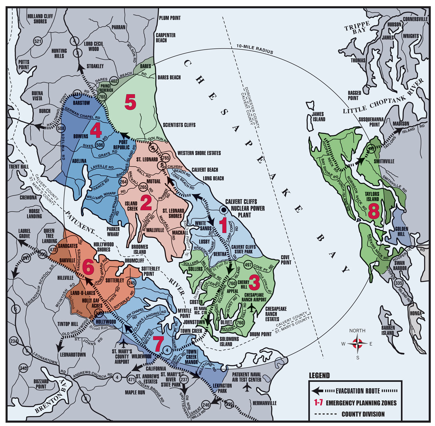
Emergency Planning Zone Map and Designated Evacuation Routes
Emergency Supplies
- General first aid kit and any special medication
- Cash, credit, or ATM cards
- Important documents
- Change of clothing
- Personal health products (toothbrush, eye care, sanitary products, etc.)
- Baby formula, diapers, car seat, toys
- Special dietary foods
- Pet related supplies
Emergency Planning Zones
The following zone descriptions will help you determine your zone. Knowing your zone number could be important in an emergency. If state or local officials direct residents to take shelter or to evacuate, the Emergency Alert System message broadcast over local radio stations and local public access cable television stations will identify the affected areas by zone number.
Zone 1
Bordered by Calvert Beach Road to the north; the Chesapeake Bay to the east; southern boundaries include Breeden Road/Sollers Wharf Road/Old Mill Road/Hellen Creek/St. Paul Branch/Route 497/Calvert Cliffs State Park; bordered by Route 2 and 4/St. Leonard Creek to the west.
Examples of Communities in Zone 1:
Calvert Beach, Calvert Beach Estates, Flag Harbor, Long Beach, Walnut Cove, White Sands, Fort Hill and Mosley Acres.
Zone 1 Includes:
Southern Middle School, St. Leonard Elementary School, Calvert Cliffs State Park, Flag Ponds Nature Park and Camp Bay Breeze.
Zone 2
Northern boundaries include Route 2 and 4/Governor Run Road; eastern boundaries include Chesapeake Bay/Route 2 and 4/St. Leonard Creek; southern boundaries include Calvert Beach Road and Patuxent River; bordered by Broomes Island Road/Nan Cove to the west.
Examples of Communities in Zone 2:
Kenwood Beach, Western Shores, Western Shores Estates, Hillside Manor, Chippingwood, Lancaster Hill, Maryland Gardens, Matapeake, Halls Hacienda, Broomes Island, Wallville, Home Place, Forest Glade, Mackall Estates, Ross Woods, Island Creek, Wallville Acres, Nostalgia, Another Place, St. Leonard Shores, Cape Leonard, Summer Solitude Estates, B Division, Old Glory, Oriole Landing, Mackall, August Run and Lost Mill.
Zone 2 Includes:
Mutual Elementary School, Rock Christian Academy, Jefferson Patterson Park, Calvert Beach Park and Norris Cove Camp.
Zone 3
Northern boundaries include Breeden Road/Sollers Wharf Road/Old Mill Road/Hellen Creek/St. Paul Branch/Route 497/Calvert Cliffs State Park; bordered by the Chesapeake Bay to the east; bordered by the Patuxent River to the south and west.
Examples of Communities in Zone 3:
Cove Point Beach, Cove of Calvert, Cove Point, Park Chesapeake Cove Estates, Brianwood, Chesapeake Ranch Estates, Drum Point, Solomons Landing, Solomons, Mill Creek, Harbour Light Beach, River View, Preston Point, Green Hills, Appeal, Hemlock Estates, Trueman Pointe, Cove View, Spruce Hill, Hellen Creek Estates, Hoopers Neck, Spring Cove, Coster, Newtown, Carol Court, Old Hickory, Chesapeake Woods, St. Johns Woods, Olivewoods, Olivet, Dowell, Asbury and Rousby Hall.
Zone 3 Includes:
Appeal Elementary School, Patuxent Elementary School, Patuxent Head Start, Our Lady Star of the Sea School, Dowell Elementary, Mill Creek Middle School, Patuxent High School Cove Point Park, Southern Community Center and the U.S. Naval Recreation Center at Solomons.
Zone 4
Bordered by Route 2 and 4 to the north; Broomes Island Road/Nan Cove to the east; the Patuxent River to the south; Route 231/Adelina Road/Sheridan Road to the west.
Examples of Communities in Zone 4:
Westlake, Woodridge, Barstow, Chapel Hill, German Chapel Woods, Patuxent Woods, Pine Trailer Park, Valley Lee, Bowens, Goodwin, Cypress Knolls, Whispering Woods, Mutual Estates, Mutual, Emerald Cove, Honey Cove Estates, Adelina, Harbor Hills, Long Cove Estates, Williams Wharf Plantation, Williams Wharf, Briscoe, Parkers Wharf, Hellen, Wells Cove, Oakland Hall and Patuxent Reach.
Zone 4 Includes:
Battle Creek Cypress Swamp Nature Center.
Zone 5
Bordered by Dares Beach Road/Cassell Road to the north; the Chesapeake Bay to the east; Governor Run Road to the south; Tobacco Ridge Road to Calvert County property gate/Main Street at Monitor Way to Calvert Towne/Route 2 and 4 to the west.
Examples of Communities in Zone 5:
Chesapeake Heights on the Bay, Dares Beach, Pendleton, Windcliff, Bayfield Farm, Bay Terrace, Hidden Valley, Calvert Towne, Parker Creek Knolls, Scientists Cliffs, Elen Acres, Port Republic, Mountain Laurel Manor and Oak Tree Landing.
Zone 6
Bordered by the Patuxent River to the north; Hollywood Road/Sotterly Gate Road to the east; Brooks Run to the south; Cat Creek Road/Sandgates Road/Route 235/Clover Hill Road/McIntosh Road/Riva Ridge Drive/McIntosh Run to the west.
Examples of Communities in Zone 6:
Hollywood, Queen Tree Landing, Sandgates, Riverwood Farms, Hollywood Shores, Winterseat, St. Mary’s Beach, Sotterly Manor, Fenwick Manor, Gillens Grove, Land-O-Lakes, Holly Gaf Acres, Drumcliff and Hillville.
Zone 6 Includes:
St. Mary’s Development Center, Three Notch Park, Judge P. H. Dorsey Memorial Park and Sotterly Mansion.
Zone 7
Bordered by the Patuxent River to the north; Patuxent River Naval Air Station to the east; Brooks Run/Broad Run/Hayden Road/St. Mary’s County Airport Drive/Cottonwood Parkway/Wildewood Parkway/Saint Andrews Church Road/Route 235 to the south; Hollywood Road/Sotterly Road to the west.
Examples of Communities in Zone 7:
California, St. Cuthbert Wharf, Clarks Landing, Scotch Point, Myrtle Point, Mill Cove, Mill Cove Manor, Kingston Manor, Holly Haven, Town Creek, Town Point, Esperanza Farms, Town Creek Manor, Town Creek Farm, Cal Acres, North Town Creek Manor, Woodland Acres, Wildewood, Middle Earth, Red Hill, Peacock Manor, Broad Run and Estates at Joy Chapel.
Zone 7 Includes:
Hollywood Elementary School, St. John’s Elementary School, Town Creek Elementary School, Esperanza Middle School, Green Holly Elementary School, Greenwell State Park, Forest Landing Recreation Area, St. Mary’s Industrial Park and Historic Sotterly Plantation.
Zone 8
Includes all of Taylor’s Island, Smithville and residents on Meekins Neck Road, Smithville Road (north of Beaver Dam Creek), and Route 16 (west of Parsons Creek).
Reception Centers and Mass-Care Centers
If you are asked to evacuate, you should go to the nearest Reception Center. You will be registered at the center. Equipment will be available to check for increased levels of radiation.
Calvert County Reception Center:
Huntingtown High School
4125 N. Solomons Island Road
Huntingtown, MD 20639
Mass-Care Center:
After registering and monitoring is complete at the Reception Center, Calvert County evacuees who need temporary shelter will be directed to a designated Mass-Care Center.
Dorchester County Reception Center:
Dorchester Career & Technology Center
2465 Cambridge Beltway
Cambridge, MD 21613
Mass-Care Center:
After registering and monitoring is complete at the Reception Center, Dorchester County evacuees who need temporary shelter will be directed to a designated Mass-Care Center.
St. Mary’s County
Points south of the Calvert Cliffs Nuclear Power Plant proceed to St. Mary’s County Reception Center.
Reception Center:
Leonardtown High School
23995 Point Lookout Road
Leonardtown, MD 20650
Mass-Care Center:
After registering and monitoring is complete at the Reception Center, St. Mary’s County evacuees who need temporary shelter will be directed to a designated Mass-Care Center.
Keep listening to your radio or TV for the latest information and instructions.
Remain calm. Do not rush